


There is something both peaceful and invigorating in the sound of a waterfall. With their power and majesty, falling water holds a unique place in the human heart. Here at Tahoe, what makes the falls especially beautiful is how the rushing water courses through shiny rock and deep forests before taking the big leap into ether.
After our poor excuse for a winter this year, the snow is melting fast, and the amount of water available to fall over the cliffs is lower than usual. So, if you want to see waterfalls, do not dilly-dally. The time to get out there is now. Here are five great waterfalls to be found on the North and West Shore of Tahoe:
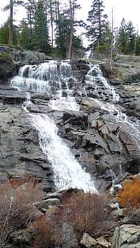
When the water is rushing, a wave of mist flows over the viewing platform at Eagle Falls. | Tim Hauserman
Eagle Falls | Emerald Bay
Lake Tahoe’s most famous falls may be seen just a few feet from the U.S. Forest Service’s Emerald Bay parking lot. Be careful to stay off the wet and slippery rocks as you gaze over the falls to Emerald Bay. A better view is found by taking the mile-long walk downhill to the Vikingsholm Castle at the edge of the lake. From there, a one-quarter mile trail leads to the bottom of the falls. When the water is really rushing, a wave of mist flows over the viewing platform, but at any time, the falls are quite dramatic.
For a more all encompassing view, take the Rubicon Trail from Vikingsholm along the edge of the north side of Emerald Bay for 1 mile to the Boat Campground. There from the end of the floating dock you get a panorama that includes not only the falls, but Maggie’s Peaks and Mount Tallac.
Trailhead: 17 miles south of Tahoe City on Highway 89. Look for the parking lot on the right side.
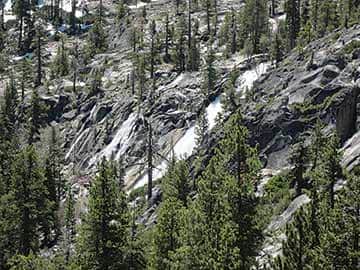
Cascade Falls ·
Cascade Falls | Emerald Bay
The trail to Cascade Falls is less than a mile from the trailhead, but is much less crowded then nearby Eagle Falls. Along the nearly level route, Emerald Bay, Cascade Lake and Lake Tahoe are viewed, before you reach Cascade’s 200-foot loud and powerful drop. Adventurers looking for more can head upstream on an unmaintained use trail to the remote and little visited Azure and Snow lakes in the Desolation Wilderness.
Trailhead: 18 miles south of Tahoe City on Highway 89 at the Bayview Campground. Drive through the campground to the trailhead.
Shirley Canyon | Olympic Valley
The falls of Shirley Canyon are not really falls as much as a series of short drops through a beautiful canyon. Follow the blue blazes along the south side of Squaw Creek. The trail winds past beautiful pools, rock sculptured by water, and quick little drops. In about 2.5 miles, including some fairly challenging steep sections over granite faces, you reach Shirley Lake, where you can turn around, or continue to enjoy a ride down in Squaw Valley’s Tram (check schedule in advance).
Trailhead: Drive through Olympic Valley, turn right at the end of the road onto Squaw Peak Road. The trailhead is just before the road starts heading uphill.
Fontanillis Falls | Desolation Wilderness
A visit to Fontanillis Falls is a truly remarkable experience, but with a 12-mile roundtrip this is not really a waterfall hike as much as a lovely romp through Desolation Wilderness with a waterfall bonus. The falls itself are a long, smooth cascade down a sloping wall of granite between Fontanillis Lake and Upper Velma Lake. While the shallow channel of water moves swiftly down the rock, the slope is not too steep and you are able to walk next to the rushing water.
To find the falls, follow the signs for 5 miles to Dicks Lake, then take a right. Wander along the Fontanillis lakeshore to the creek coming out of its northern edge, and follow the stream down toward Upper Velma Lake. From there you can join the Velma Lakes trail and make your way back to Emerald Bay.
Trailhead: See the trailhead for Cascade Falls.
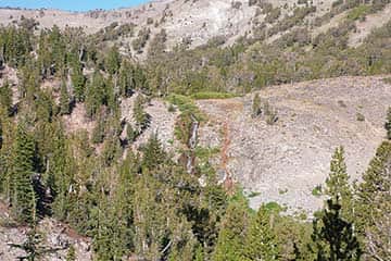
Galena Falls makes an excellent lunch spot along the Tahoe Rim Trail. | Tim Hauserman
Galena Falls | Tahoe Meadows
Just an easy 2-mile hike on the Tahoe Rim Trail gives you awesome views of Lake Tahoe and Mount Rose before you reach the popular Galena Falls. From the bottom of the falls, you can follow the TRT as it winds its way to the top, and find an excellent lunch spot next to the rushing water.
Trailhead: Take Highway 431 8 miles from Incline Village to the Tahoe Rim Trail-Mt. Rose Trailhead on your left.


