


When I’ve thought of Donner Summit for outdoor pursuits, my focus has been on skiing at Royal Gorge Cross Country in the winter, hiking up to Mount Judah on the Pacific Crest Trail in the summer and the classic road bike from Donner Lake to Cisco Grove in the spring and fall. Recently, however, I discovered something new and fun to do on Donner Summit: mountain biking the network of trails created and enhanced at Royal Gorge by Truckee Donner Land Trust. In combination with the Royal Gorge ski trails, the recently built Hewlett Rim Trail brings riders and hikers past wildflower dotted grassy flats, through deep forests of giant firs and up to spectacular canyon vistas at the top of Rowton Peak.
The Trail
Royal Gorge Rim Trail | 13 miles RT | Moderate
Download the trail map
The first thing you want to do when it comes to riding the trails at Royal Gorge is don’t do what I did, which is show up at the trailhead on a smoky day. I climbed out to the Bill and Flora Point, and to the top of Rowton Peak, and sure, I could tell the views from there would be spectacular when the smoke cleared, but on that smoky day, there was a whole lot of possibility. No worries, the ride itself was worth it with a lovely forest, lots of wildflowers and some fine single-track trail.
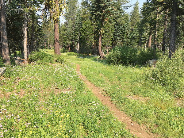
The trail was a super fun, rolling downhill with flowy turns … Once I hit Claim Jumper Trail, the fun continued with a gentle downhill single track through a lush carpet of wildflowers.
I ended up riding about 10 miles from the Hoelter Hall trailhead, which is located just before the end of Soda Springs Road above Ice Lakes. The loop I was planning on riding was more likely close to 7 miles, but I was having so much fun on some of the lower trails that I decided to wander around and extend the ride. Be sure to bring along a copy of the Land Trust map and take a gander at it every time you see a Royal Gorge ski area sign — they pop up pretty frequently. When you see how tall those signs are, you will be reminded that it snows a lot on Donner Summit. Still, you may end up riding a different route than you planned. The trail network is extensive with lot of unmarked use trails thrown in to confuse us. It’s all good, you can’t really get too lost just don’t ride with a tight deadline.
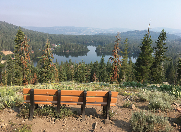
I rode up to Rowton Peak counterclockwise. This meant that I quickly reached the Bill and Flora Point viewpoint with expansive canyon views. Good thing I took a quick break because the toughest section of the ride was up next — a super steep switchbacking trail paralleling Bogus Basin ski area that forced me to get off my bike several times on the tight switchbacks. Eventually, Hewlett Rim Trail met a Royal Gorge ski area road, where a lovely view of Serene Lakes unfolded below, and several benches awaited my posterior.

Now the riding got easier, starting with a gentle rise to Bogus Basin Hut and then a well-graded switchbacking single track winding past asters and pennyroyal on the long climb up to Rowton Peak. From the top, the view of the canyon below is extraordinary
From Rowton Peak, my choices were to climb up Razorback Ridge Trail with its cliff-topping views to the south or take the more gently rolling Bogus Basin Trail on a long jaunt to its junction with Claim Jumper Trail. I chose the latter and was happy with the decision. The trail was a fun, rolling downhill with flowy turns that were just within my skill level. Once I hit Claim Jumper Trail, the fun continued with a gentle downhill single track through a lush carpet of wildflowers.
When I reached a junction with Switchback Trail, I hung a right to put in some extra distance through rolling grassy terrain that was a blast to ride, before turning around and heading back to that Claim Jumper/Switchback junction. There I got a bit confused trying to locate the route back to the trailhead. Look for a steep uphill on a double-tracked old road that looks bright white; it will shortly reach another Switchback sign, which you follow back to the trailhead.
I’d like to head back to check out the Royal Gorge trails again for three reasons. First, I want to partake of the views. Second, once I’m familiar with a trail, I have more confidence taking on the twists and turns. Third, I only touched the surface of the trails. I could also ride out to Point Mariah or to Lyle’s Lookout.
The trail network dishes out a variety of trails of difficulty from easy rolling terrain to some steep switchbacks. Intermediate riders should have fun with all the terrain, although some may need to get off their bikes on a few switchbacks. I would not recommend the trail for beginning mountain bikers.
There are also several hiker-only trails. One goes straight from the trailhead to the viewpoint on Rowton Peak making for a 5-miles roundtrip hike with a lot of view bang for your distance buck. | truckeedonnerlandtrust.org


