


By Mark McLaughlin ·
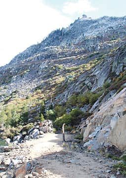
Remains of the Dutch Flat road may be seen on the Summit Canyon trail. ·
Editor’s Note: Part I may be found at TheTahoeWeekly.com.
The original Donner Pass on historic Highway 40 is arguably one of the most significant square miles in the United States. Its legacy encompasses Native American travel and trade, pre-Gold Rush pioneers, the nation’s first transcontinental railroad and highway systems, as well as the vanguard of cross-country aviation.
Through the efforts of the Truckee Donner Land Trust and its many donors and volunteers, significant tracts of land have been purchased by the trust including most of the land surrounding Donner Lake, including Summit Canyon, a 260-acre jewel west of Donner Lake and east of Donner Summit. This acquisition of critical watershed drainage is now part of Donner Memorial State Park. The Land Trust’s purchase has permanently protected an important ecosystem that is now freely accessible to the public for exploring and recreation.
The first improved road over Donner Pass was built in the 1860s by Central Pacific Railroad as a toll route to siphon lucrative Comstock traffic from the prominent Carson Pass south of Lake Tahoe. Mistrust of the railroad’s true intents, however, ran rampant throughout California. CPRR’s Chief Engineer Theodore Judah also suspected that the toll road was just a money-making ruse to avoid construction of a Pacific Railroad over the mountains. In desperation, Judah traveled to New York City to drum up investors to take over the company, but he died shortly after his arrival from Yellow Fever contracted while crossing the Panamanian tropics.
Judah may have been the most vocal critic of the so-called Dutch Flat-Donner Lake Wagon Road, but he wasn’t the only opponent. San Francisco investors, Sierra Nevada miners and even the general public began to believe that the CP was focused only on getting its line built to Dutch Flat, well west of Donner Summit. Some Californians even thought the whole railroad construction project was just a scam and that no one, not even “Crazy Judah,” had figured out a practical route through the Sierra range.
No one could know for certain the intentions of CP’s directors, but the perception of greed raised the ire of many. Numerous articles and pamphlets arguing against the “Great Dutch Flat Swindle!” flooded the press.
San Francisco’s Alta California editorialized, “The Sacramentans [CP directors] are determined to have no railroad but Dutch Flat. The Capital City has aided in the raid upon this county for $80,000, upon Placer County for $25,000, and upon the state for millions. There will never be a railroad via Dutch Flat to Nevada Territory. There are obstacles which cannot be overcome. The Pacific Railroad will follow another route, not through Sacramento or anywhere else in the vicinity.”
Despite the intense backlash, there was never any foundation to the stories spread by detractors of the railroad. Judah’s successor as Chief Engineer, Samuel S. Montague, was immediately ordered to continue surveying the future route well into Nevada. Obviously, there was no doubt among CP’s directors that the Central Pacific line would eventually connect with the Union Pacific somewhere in Utah or Nevada. By June 1864, the controversial wagon road linking Sacramento to the Comstock mining district was finished and the company proclaimed the toll road open. The route was an immediate success and it lured throngs of teamsters from the Carson Pass route.
During the early decades of the 20th-century there was a revolution in transportation technology when cars and improved roads began making mountain travel easier, more accessible and more fun. During the 19th-century, railroads had dominated interstate transportation of people and goods. However, the growing popularity of automobiles led a group of car enthusiasts and automotive industry officials to establish the Lincoln Highway Association in 1913.
Among its stated goals was to “establish a continuous improved highway from the Atlantic to the Pacific, open to lawful traffic of all description without toll charges.” It was a bold vision for this nation 100 years ago, where roads were primarily of interest only to local residents as most streets ended outside city limits. In the surrounding countryside, so-called market roads were poorly maintained by counties or townships.
By that time, marketing to the rapidly growing auto-based tourist economy had become firmly established and it hasn’t let up since. Even though the Lincoln Highway was not yet complete over Donner Pass, in 1910 Valvoline Oil Company sponsored a round-trip car race from Sacramento to Lake Tahoe with a large trophy as the prize.
Not to be outdone, in the spring of 1911 the Tahoe Tavern hotel at Tahoe City offered its own silver trophy and bragging rights for the first party to drive a motor vehicle that year from California over the Donner Summit to the luxury hotel. The operators of the Tahoe Tavern wanted to ramp up Tahoe City’s early season tourist business and to generate advertising headlines in the San Francisco newspapers.
Highway 40 replaced the crude Donner Lake Wagon Road. Decades later, after its completion in the early 1960s, the modern superhighway that is Interstate 80 absorbed virtually all of the trans-Sierra traffic between Reno and Sacramento leaving just ghosts of the first routes over the summit. Fortunately, interested travelers exploring the summit portion of Highway 40 can look carefully and still see the remains of the Dutch Flat road, a tangible legacy to our region’s dramatic past. This and other forgotten trails are now open for free public access just west of Donner Lake in the newly added Summit Canyon portion of California’s state park system.
To start your tour of discovery, drive west along Donner Lake on Old Highway 40 (Donner Pass Road) past South Shore Drive and up the mountain about one-third of a mile. The trailhead with a small parking lot is on the left. It’s about 3 miles from the trailhead to Donner Pass with a 1,000-foot elevation gain.
There is much to see, especially along the upper portion of the route, including gorgeous mountain scenery, 2,500-year-old Indian petroglyphs, the Sierra China Wall and massive railroad snow sheds. Explore as little or as much as you want; make it easier with a car shuttle or start from the top instead. It’s worth checking out.
For more info on Summit Canyon and the Truckee Donner Land Trust, visit tdlandtrust.org.
Tahoe historian Mark McLaughlin is a nationally published author and professional speaker. His award-winning books are available at local stores or at thestormking.com. You may reach him at mark@thestormking.com. Check out Mark’s blog at tahoenuggets.com.


