


By Mark McLaughlin ·
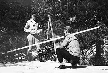
Central Sierra Snow Laboratory staff measure water content near Donner Pass in March 1946. | Courtesy Mark McLaughlin ·
Summer is almost here and water sports will soon be on everyone’s mind. Most people realize by now that the winter of 2015, the least snowy of record, added little moisture to the Tahoe Basin. Lake Tahoe’s water level is forecast to remain basically unchanged this spring with no seasonal rise and no flow out of the Tahoe Dam for river rafting on the Truckee.
Despite disappointing runoff, Big Blue is still nearly 3 feet higher than it was in the early 1990s. And, a short drive will take you to Independence Lake north of Truckee, where waters levels are at 95 percent of capacity.
When hydrologists measured water content in the Sierra snowpack in May 2015, readings were the lowest in a century and the worst of record for virtually every site. This winter’s generally high snow levels are reflected in May measurements across Nevada and the eastern Sierra where only 16 out of 88 snow survey sites had any snow at all.
Many people are familiar with these monthly surveys carried out by government agencies, when surveyors, sometimes followed by media cameras, manually poke a hollow aluminum pipe into the snowpack to weigh its water content. Hydrologists and anyone who relies on Sierra snowmelt are focused on how much water is in the pack, not its depth. Snowmelt supplies more than 75 percent of the total freshwater supply for the western United States.
Snow surveying rooting in Tahoe
Manual snow surveying may seem like an old and arcane system, but, in fact, this accurate and internationally accepted science has its roots right here in Tahoe. The earliest studies of our vital mountain snowpack began with Dr. James E. Church, a Michigan native who was hired as a professor in 1892 by the University of Nevada in Reno. Shortly after his arrival in Reno, however, Church was ready to return home after he watched a man shot in a saloon gunfight die at his feet. Lucky for us, he gazed up at majestic Mount Rose towering above the city and decided to stay
Known as the Father of Snow Surveying for his pioneering work in developing the science during the early 20th Century, Dr. Church established the first Sierra weather observatory atop 10,776-foot-high Mount Rose in 1905. Church got into the stream flow forecasting business by accident. His original research investigating forest influences on mountain snowpacks led him to design the Mount Rose Snow Sampler, the hollow metal tube with serrated teeth at one end. A sample core is then weighed on a specially calibrated, portable scale to determine its water content, a simple but effective system that is still used today.
Church conducted his first snow surveys at Lake Tahoe where the current Tahoe City Golf Course is located. He worked closely with a professor of civil engineering at the university to develop the complex mathematical formula by which snow survey measurements are converted into water runoff forecasts. For decades, California and Nevada were locked in a bitter water war over the Truckee River, but by providing stream flow forecasts to better manage storage in Lake Tahoe, Church’s new forecasting tool helped subdue the conflict.
In the 1930s, government agencies took over snow surveying. Church retired from teaching at the University of Nevada and spent all his free time on snow research. Despite the 1950s Cold War, he shared his expertise with other countries around the world that relied on mountain snowmelt. Church worked with leading Russian scientists and directed snow-surveying parties into the Himalayas. He also helped Argentina and Switzerland improve their water management systems. Church was a strong advocate of positive international relations and once said, “I went forth in search of science, but I found humanity instead.”
Snow lab built at Soda Springs
Dr. Church made many important contributions to our understanding of the Sierra snowpack, but he was not a trained scientist and could not delve into the complex physics inherent in this massive frozen reservoir. The first stages of this critical research began during World War II when government physicist, Dr. Robert Gerdel, moved to Sacramento to establish the Central Sierra Snow Laboratory at Soda Springs.
Robert Gerdel was born in 1901 and grew up in Escanaba, Mich. When he was 12-years-old, a botched surgical procedure left him clinically deaf. The local doctor had performed a successful tonsillectomy on the Gerdel family’s kitchen table, but an infection set in that damaged his ear canals. Losing your sense of hearing is a life-changing event, but Gerdel never let this physical handicap interfere with his plans to become a scientist.
His high school principal tried to have him committed to a school for the deaf, but Gerdel successfully persuaded the administrator to give him a chance. He learned to lip-read, checked the lecture notes of his fellow students, and graduated with good grades. Despite his disability, after high school Gerdel went on to earn master and doctorate degrees from Ohio State University.
In 1943, Dr. Gerdel and his family moved to Sacramento where he spent two years designing the snow laboratory. While the physical facilities of the laboratory were still in the planning and building stages, Gerdel installed temporary weather instruments behind the Soda Springs Hotel near Donner Pass.
During this time, he and Church shared a small cabin behind the Soda Springs gas station, which they used as a base to conduct their related, yet separate, research. Over his career, Church had frequently complained about the lack of government funding for his work, but Gerdel, who was deaf, never really heard much about it.
In addition to Church’s snow sampler, today’s hydrologists utilize snow pillows, Gamma Ray detectors and satellite imagery to measure water content. NASA is already working on a more comprehensive system with its Airborne Snow Observatory mission. Several agency aircraft are now equipped with a scanning radar and laser device called LIDAR, technology that is at the cutting edge of remote-sensing science. Test flights over the Sierra Nevada are already producing accurate snow depth and water content maps.
The current focus is the remote Tuolumne watershed and its Hetch Hetchy Reservoir, which combined represent the primary water supply for 2.6 million San Francisco Bay Area residents. The threat of climate change and its inherent challenges to the state’s extensive water system make this work more important than ever.
Tahoe historian Mark McLaughlin is a nationally published author and professional speaker. His award-winning books are available at local stores or at thestormking.com. You may reach him at mark@thestormking.com. Check out his blog at tahoenuggets.com, or read more Sierra Stories at TheTahoeWeekly.com.


