


By Mark McLaughlin
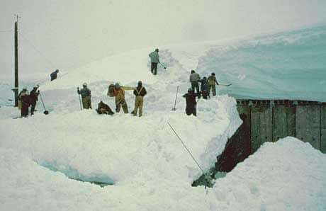
Southern Pacific Railroad crews shovel snow sheds on April 30, 1983. | Courtesy Mark McLaughlin
[blockquote3]
“It’s time to put these bleak statistics in the rearview mirror. There is a strong El Niño brewing in the Pacific Ocean, which will most likely have a strong influence on this winter’s storm patterns in the Tahoe Sierra.”
[/blockquote3]
In the West, precipitation (rain combined with melted snow) is usually measured in water years as opposed to calendar years. In the Sierra Nevada, the water year runs from Oct. 1 to Sept. 30. Historically, Oct. 1 is the date of minimum stream and reservoir levels in California, as well as the start of the rainy season. In the mountains virtually all precipitation occurs between Nov. 1 and May 1, so it makes sense to measure annual precipitation seasonally.
Since the 2015 water year wrapped on Sept. 30, let’s take one last look at last winter. Although 2015 was indeed a record breaker for its minimum snowfall, precipitation in the region was almost respectable. Surprised? Winter 2015 was characterized by prolonged dry spells interrupted by moisture-laden Atmospheric Rivers that delivered significant rain to the Tahoe Sierra, but with snow only at the higher elevations.
These Atmospheric River (AR) storms, known colloquially as a Pineapple Express, are a big deal when it comes to winter weather. On average, about 30 to 50 percent of annual precipitation on the West Coast occurs in just a few AR events, and they are a vital component in our winter climate. These relatively narrow and slow-moving bands about 250 to 300 miles wide, draw deep subtropical moisture across the Pacific Ocean past Hawaii.
Driven by high-altitude winds, an AR can move huge amounts of water in the atmosphere. A strong event can transport an amount of water vapor equivalent to the volume of water flowing near the mouth of the Mississippi River. California typically experiences up to six ARs each winter, and they can collectively provide nearly half of the state’s freshwater supply.
At the Central Sierra Snow Laboratory near Donner Pass, lab manager Randall Osterhuber measured nearly 42 inches of precipitation during the 2015 water year. That’s only about 20 percent less than the 51.5 inches measured in an average year. In fact, since 1871, there have been nearly 50 other winters that were drier than 2015; even 2014 had less precipitation than last winter.
Snowfall, however, is a much different story. Only 130 inches of snow were tallied in 2015 at the lab, which is located at 6,883 feet in elevation. That is way off the normal 34 feet that usually buries the area each winter. It ranks as the No. 1 least snowy winter since snowfall measurements began in 1879. That broke the long-held miserly record of 153 inches set in 1881. Two years ago, everyone thought the winter of 2013 was really lame for poor snowfall, but that year 215 inches fell at the lab, about 7 feet more than 2015.
These numbers clearly illustrate how deplorable last winter was snow-wise in the Tahoe Sierra. Thank goodness for resort investment in expanded snowmaking systems and state-of the-art grooming machines that made many ski days quite enjoyable. If this had happened a decade or two earlier, we would have been toast. Ski areas that did not have snowmaking or enough of it in 2015 didn’t have a chance.
The April 2015 survey of snowpack water content was the lowest in a century and the worst of record. Out of five measurements taken once a month from January to May, the April survey is the most critical for forecasting runoff because statistically it represents the maximum water content in the Sierra snowpack. These data are crucial for water management in California and western Nevada.
At the majority of survey sites located in the Truckee and Lake Tahoe basins, new record-low water measurements were set. Four of the snow course locations in our immediate area date back to 1910 and are the oldest in the United States thanks to Dr. James Church, a University of Nevada, Reno professor who established them in his early efforts to predict runoff in the Truckee River.
Two of the upper elevation courses, Ward Creek #2 and Donner Summit, set new minimum records for water content. This year, the Ward Creek site was snow free on April 1 for the first time since the course was established in 1913. Out of nine courses in the Tahoe Basin, Mount Rose was the only one with snow in the April snow survey. There are four, century-old snow courses in the area, and only Mount Rose (1910) had measureable water content coming in at the third lowest after 1926 and 1931. Mount Rose’s high elevation above 9,000 feet made a big difference in 2015, a winter when mostly rain fell below 7,500 feet.
The length of the current drought at four years is well within the natural variability expected in our erratic, Western climate, but lack of snowfall in 2015 was extreme and unprecedented. There has been a trend for significantly drier than normal Januaries in the past decade. Normally the wettest month of the year, in January 2015 virtually no precipitation fell. Even during January 2011, a Top 10 snowfall winter, the month was below normal in precipitation.
In San Francisco, the month of January in 2015, 2014 and 2013 all rank in the top five driest since records began in 1850. Since 2005, January precipitation is off about 30 percent, a significant deviation from the average. It’s difficult to reach seasonal norms with snowfall and precipitation when January is dry as a bone. Those three winters also all rank in the Top 10 for least annual snowfall at Donner Pass.
But it’s time to put these bleak statistics in the rearview mirror. There is a strong El Niño brewing in the Pacific Ocean, which will most likely have a strong influence on this winter’s storm patterns in the Tahoe Sierra. The two previous ENSO events of this magnitude occurred during the winters of 1983 and 1998. Both were exceptionally wet. I’ll review those two extraordinary years in future columns.
No matter what the winter of 2016 has in store for us, our mountain weather has the ability to change moods in a flash, so visitors and locals should always pay attention to the forecast and keep their eyes glued to the sky. Author Robert Heinlein got it right when he wrote, “Climate is what you expect. Weather is what you get.”
Tahoe historian Mark McLaughlin is a nationally published author and professional speaker. His award-winning books are available at local stores or at thestormking.com. You may reach him at mark@thestormking.com. Check out his blog at tahoenuggets.com, or read more Sierra Stories at TheTahoeWeekly.com


