


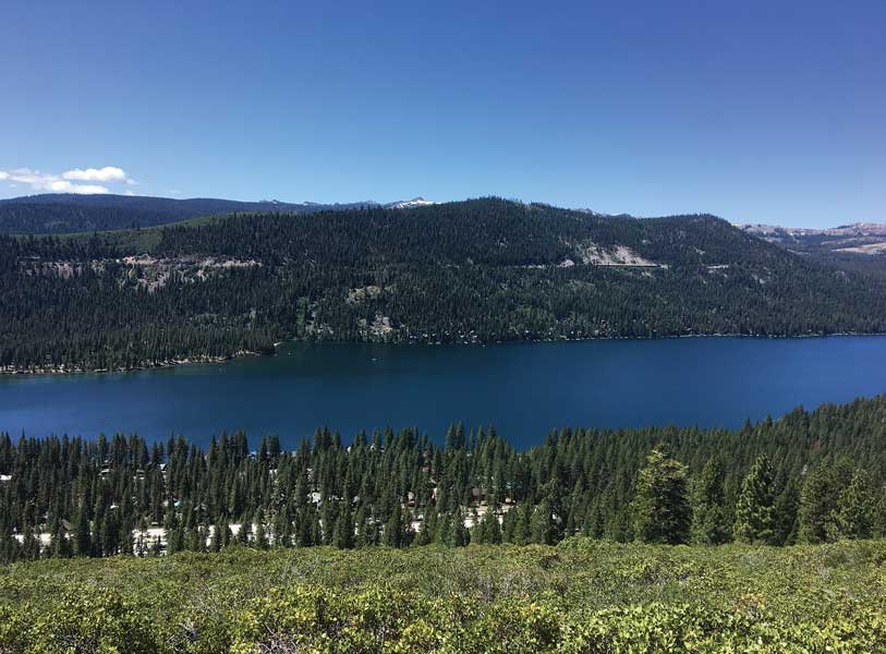
Given the amount of time I’ve spent hiking trails around Lake Tahoe, it’s a special treat to find a new ribbon of dirt that provides a different perspective of the places I’m so familiar with. I had that treat recently by hiking a section of the Donner Lake Rim Trail that was completed last summer. It heads west from Northwoods Boulevard in Tahoe Donner for about 4.5 miles to connect with an existing section.
The new route provides expansive views of Donner Lake and the Pacific Crest and connects with an equally beautiful section to allow for a 10-mile, point-to-point hike.
The new route provides expansive views of Donner Lake and the Pacific Crest and connects with an equally beautiful section to allow for a 10-mile, point-to-point hike to the Wendin Way trailhead at the Donner Lake exit off Interstate 80. When completed, the Rim Trail will be 23 miles long encircling Donner Lake.
The Trail
10 miles one way
Moderate to strenuous
This hike has about 1,500 feet of ascent with 1,300 feet of descent. The first 7 miles to the Drifter Hut are all uphill, but the grade is designed to accommodate mountain bikers. So except for a few hairpin turns, it never feels steep. Once the climbing is completed, you descend 1,300 feet in just 3 miles. A car shuttle is easy to arrange with only about 6 miles of road between the trailheads.
The trail begins across Northwoods Boulevard from the Trout Creek Bike Trail parking lot, which heads from Tahoe Donner to downtown Truckee. Carefully and swiftly cross very busy Northwoods to the trail, which winds next to the Donner Crest development before reaching a shady forest of white fir and Jeffrey pine. There are lots of side trails to send you astray along the route, so keep your eyes peeled for Donner Lake Rim Trail signs.
At three-quarters of a mile you reach a secondary trailhead at Bermgarten Road. You can use this trailhead to not only shave some distance, but also avoid the mad dash across Northwoods. The trail continues to meander steadily west through manzanita and pines until at about 2 miles in you get a teaser glimpse of Donner Lake. A bit farther and the world opens wide to a half-mile of spectacular Donner Lake and Pacific Crest views from a treeless slope of manzanita. While driving into Truckee from Donner Summit, you have probably often wondered how good the view is from those big houses on top of the brushy slope looking toward Donner Lake. The trail sits just below that view and it is awesome.
While you do have to climb back into the trees, no worries, you get a break from the sun as you switchback through the shady forest to the top of the ridge. Here at 7,000 feet, a carpet of mule’s ears and stickseed cover the ground. This might be the biggest display of stickseed I’ve seen. They wave pretty purple flowers in the summer, but then the Mr. Hyde side comes out — those flowers turn into sticky burrs in the fall. Brushing up against these plants at the wrong time will fill your socks with dozens of hard-to-remove thorny buggers.
At about 4.5 miles, the views arrive again and are now primarily of the top of the Pacific Crest from Donner Summit to Tinker Knob. If you are ready for a rest, two picnic tables await your posterior.
Next the trail gets a bit confusing. Focus on heading west as you turn left on an old dirt road. Then the trail heads off to the right just above a Donner Lake overview bench.
Over the next 2.5 miles the trail rolls through mostly treeless terrain to the ridge above Johnson Canyon, which you follow north enjoying views of the deep canyon, as well as Castle Peak and Frog Lake Cliffs to the north.
The top of the climb is Drifter Hut, a challenging destination for Tahoe Donner Cross Country Nordic skiers. From there, the trail takes a dive down into Johnson Canyon via more than a dozen switchbacks. If you have bad knees, this might be a good time for hiking poles. The terrain is diverse with ferns in the moist shade and reddish-black volcanic-rock formations commanding the dry ridgeline above. In another 1.5 miles, just after passing the only water source on the trail, the trail splits and heads toward Donner Summit while the Wendin Way connector leads to the hike’s end near Interstate 80.
“It officially opened last August. We are really excited to have the whole northern half of the Donner Lake Rim Trail done,” said Greyson Howard, Truckee Donner Land Trust’s communications director. “Since 1993, this trail has been the cornerstone project of the Truckee Donner Land Trust.”
Next step for the trail builders is Schallenberger Ridge, which sits on the southern side of Donner Lake above the railroad tunnels.
“We are working closely with Placer County, which will make this section also part of a new Memorial Overland Emigrant Trail,” said Howard. | truckeedonnerlandtrust.org
Pros to this hike
Unique and spectacular views of Donner Lake and the Sierra Crest. A steady, well-graded trail makes 1,500 feet of climbing not seem as hard as it sounds.
Cons to this hike
It’s a busy trail with lots of mountain bikers, runners, dog walkers and hikers. There is no water for the first 8.5 miles of the trail. Either don’t bring your dog or bring lots of extra water for it.


